DO YOU HAVE ANY QUESTIONS?
THANKS!
REQUEST HAS SENT
WE WILL CONTACT YOU SHORTLY


SERG TOMAKH
DEVELOPMENT MANAGER
Or contact us via email hello@omegarender.com


SITE PLAN 3D RENDERING SERVICES
CONTACT US TO GET PERSONAL OFFER
THANKS!
REQUEST HAS SENT
WE WILL CONTACT YOU SHORTLY
SERG TOMAKH
DEVELOPMENT MANAGER
BRING YOUR VISION TO LIFE WITH OMEGARENDER
OUR 3D SITE PLAN RENDERINGS TRANSFORM COMPLEX IDEAS INTO CLEAR, COMPELLING VISUALS. WE HELP ARCHITECTS, DEVELOPERS, AND DESIGNERS SHOWCASE THE SCALE, INFRASTRUCTURE, AND SEAMLESS INTEGRATION OF THEIR PROJECTS WITH THE SURROUNDING ENVIRONMENT—ALL IN STUNNING DETAIL.
INSPIRED SOLUTIONS FOR IMPACTFUL PRESENTATIONS
WITH OUR RENDERS, YOU’LL GAIN A POWERFUL TOOL TO COMMUNICATE EFFECTIVELY WITH CLIENTS AND INVESTORS. WE CREATE VISUALS THAT DO MORE THAN INFORM—THEY INSPIRE. PARTNER WITH OMEGARENDER TO HIGHLIGHT THE UNIQUENESS OF YOUR CONCEPT AND MAKE YOUR VISION UNFORGETTABLE.
CONTACT US TO GET PERSONAL OFFER
THANKS!
REQUEST HAS SENT
WE WILL CONTACT YOU SHORTLY
SERG TOMAKH
DEVELOPMENT MANAGER
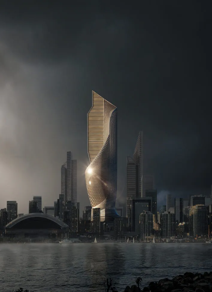
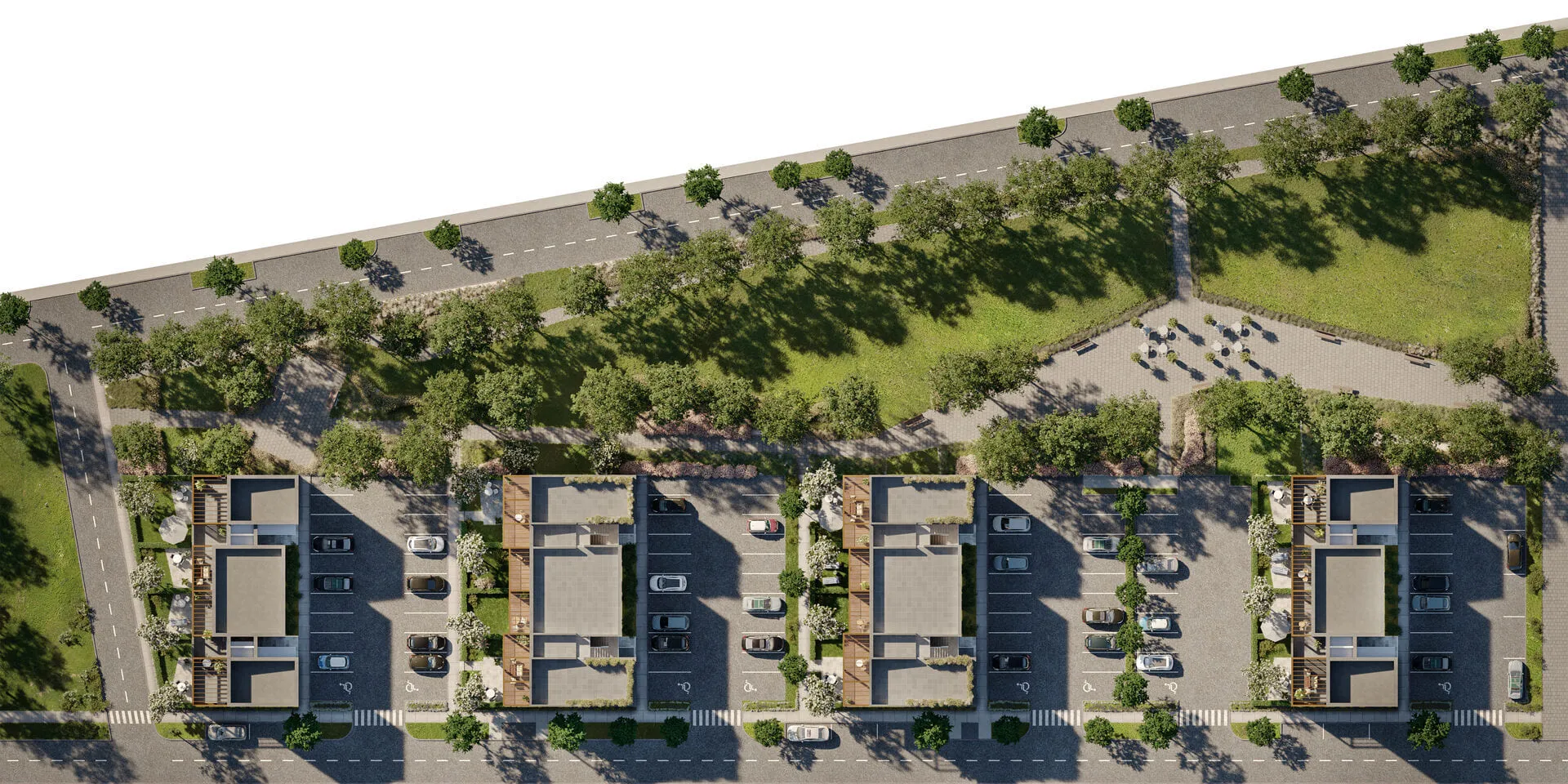
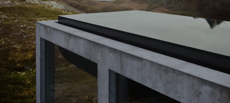
SOME OF OUR WORKS
PRODUCING IMAGES THAT YOU WANT TO BE IN, WE’RE CREATING A POWERFUL NON-EXISTENT REALITY. 3D RENDERING FOR ARCHITECTS, DEVELOPERS, BRANDING AGENCIES AND PRODUCT DESIGN COMPANIES.


Marcos Arana
key Account manager
I'M HERE TO HELP CREATE THE BEST IMAGES FOR PROJECT PRESENTATIONS.
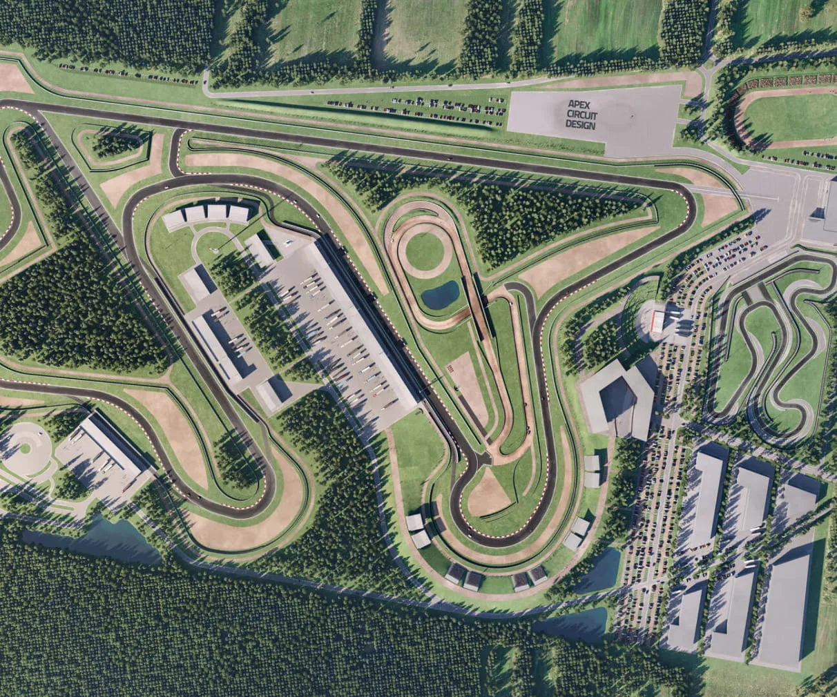
WHAT A 3D SITE PLAN RENDER IS
IT IS A TYPE OF A BIRD VIEW WHEN THE OBJECT IS DEPICTED FROM A GREAT HEIGHT AT AN ANGLE OF 90 DEGREES, WHAT IS ALMOST PERPENDICULAR TO THE MAIN FACILITY. THIS TYPE OF VISUALIZATION IS USED TO SHOW THE INFRASTRUCTURE, ROADS, AND MOVEMENT, HOW THE OBJECTS ARE CONNECTED WITH EACH OTHER, AND THE SCALE OF BUILDINGS WITH RESPECT TO ONE ANOTHER. IN OTHER WORDS, SUCH A VIEW SHOWS THE WAY THE OBJECT ITSELF INTERACTS WITH THE ENVIRONMENT, HOW IT IS ARRANGED IN IT, AND WHAT ELEMENTS AND CONSTRUCTIONS WILL BE NEARBY. ALSO, SITE PLAN 3D RENDERING SERVICES FOCUS ON ROADWAYS AROUND. IT IS NECESSARY TO DISPLAY THE SCHEME OF HOW THE ROADS LEAD TO A RESIDENTIAL COMPLEX OR HOW THE GREEN ZONES INTERWEAVE WITH THE SURROUNDING IN ORDER TO UNDERSTAND THE REAL PROPORTIONS OF THE BUILDING AND THE LANDSCAPE DESIGN. SUCH MASTER PLANS ARE ALSO USED TO SHOWCASE THE NUMBER OF OBJECTS AND IN A NON-SCHEMATIC FORM TO CONVEY WHERE EACH STRUCTURE WILL BE LOCATED, IN OTHER WORDS, IT IS A MAP IN FACT.
AS YOU MIGHT HAVE ALREADY UNDERSTOOD, THE 3D SITE PLAN RENDER IS SIMILAR TO THE AERIAL VIEW. STILL, THERE ARE SEVERAL FUNDAMENTAL DIFFERENCES:
•THE CAMERA IS DIRECTED CLEARLY DOWNWARD WITHOUT APPEALING TO THE STANDARD PERSPECTIVE OR THE DEPTH OF FIELD;
•LESS FOCUS ON PRESENTATION AND DECORATION, MORE ON CLARITY OF DETAILS;
•DEPENDING ON THE SCALE, THEY WILL DIFFER IN THE HEIGHT OF THE CAMERA, AND THE SITE PLAN WILL ALWAYS BE FARTHER THAN THE AERIAL AS THE SITE PLAN NEEDS TO DIRECTLY SHOW THE INTERACTION WITH THE ENVIRONMENT. THE BIRD VIEW ALSO ALLOWS YOU TO DO THIS, BUT THE SITE PLAN MAKES IT A LITTLE MORE VOLUMINOUS.
WHO PROVIDES THE 3D SITE PLAN RENDERING SERVICES
3D SITE PLAN RENDERING COMPANIES HAVE DIFFERENT SPECIFICS AND YOU NEED TO PAY ATTENTION TO THE PORTFOLIOS OF THESE FIRMS, TO THEIR EXPERIENCE IN THE IMPLEMENTATION OF SUCH CASES AND TO THEIR WORKFLOWS.
NO MORE THAN TWO SITE PLAN RENDERING VIEWS CAN BE INCLUDED IN ANY PROJECT, EVEN IF IT IS A LARGE-SCALE AND VERY VOLUMINOUS PROJECT. AFTER ALL, THE HIGH POSITION OF THE CAMERA ALWAYS ALLOWS YOU TO CAPTURE ANYTHING AND THIS ANGLE PROVIDES THE ABILITY TO RENDER EVEN THE WHOLE CITY. OUR STUDIO HAS CASES OF PROVIDING SITE PLAN 3D RENDERING SERVICES WHEN WE RENDER SMALL CITIES IN 20K PIXELS TO HAVE AN OPPORTUNITY TO MAKE CROPS, ZOOM, CAMERA SPANS AND SO ON.
AUDIENCE
3D SITE PLAN RENDERING SERVICES ARE NEEDED PRIMARILY FOR:
•URBANISTS;
•LANDSCAPE ARCHITECTS;
•BUILDING ARCHITECTS;
•DEVELOPERS;
•LARGE REAL ESTATE AGENCIES;
•GENERAL CONTRACTORS.
DESIGNERS AND ARCHITECTS APPLY TO 3D SITE PLAN RENDERING COMPANIES TO PERFORM THEIR PROJECT IN REALISTIC SHAPE. AS FOR REAL ESTATE AGENCIES, THEIR AIM IS TO SHOW THE INFRASTRUCTURE ENVIRONMENT, LANDSCAPING, THE DEVELOPMENT AREA AND, OF COURSE, ALL VISIBLE OBJECTS THAT WILL GO FOR REDEMPTION, DELIVERY, ETC. SUCH RENDERS ARE A GOOD ADVERTISING DEMONSTRATION OF NOT A CERTAIN HOUSE OR OBJECT BUT THE ENTIRE AREA.
WORKFLOW OF 3D SITE PLAN RENDERING COMPANY
3D SITE PLAN RENDERING SERVICES ASSUME A STANDARD WORKFLOW, WHICH YOU CAN GET ACQUAINTED WITH IN THIS LINK. NEVERTHELESS, THERE ARE TWO IMPORTANT POINTS THAT ARE TO BE SPECIFIED IN ADVANCE. BEFORE WE START WORKING YOU NEED TO INFORM OUR PROJECT MANAGER ABOUT THE FOLLOWING:
•THE RADIUS THAT THIS IMAGE WILL CAPTURE;
•HOW THE ENVIRONMENT WILL LOOK LIKE.
THE SECOND POINT IS ABSOLUTELY CRUCIAL WHEN YOU BUILD THE ENTIRE DISTRICT. YOU CAN USE PHOTO INTEGRATION, IT IS A TYPE OF SITE PLAN 3D RENDERING SERVICES WHEN THE DRONE FROM ABOVE HEIGHT CAPTURES THE AREA, AND THE VISUALIZED OBJECT IS ALREADY INSERTED AFTERWARDS. THE OTHER WAY IS MASSING OR WHITE BOX RENDERING, WHEN WE PLACE TRANSLUCENT BOXES IN ORDER TO SIMPLY DEPICT THE SCALES OF THE OBJECTS STANDING NEXT TO THEM - READ ALSO VIRTUAL STAGING SERVICES. THE LAST OPTION IS THE ENVIRONMENT THAT FULLY CORRESPONDS TO WHAT EXISTS IN REALITY AROUND THE SITE OF THE FUTURE DEVELOPMENT. ACCORDINGLY, WE WILL TAKE A DIFFERENT APPROACH, FOR EXAMPLE, TAKE THE SURROUNDINGS FROM GOOGLE MAPS. OTHERWISE IF THERE IS NO NECESSARY ENVIRONMENT, OR THE BUILDINGS ARE STILL COMPLETELY NEW, OR THEY HAVE CHANGED OVER TIME, THEN WE CAN CREATE ALL THIS IN FULL 3D IN ORDER TO CREATE THE MOST PHOTOREALISTIC PICTURE THAT WILL IDEALLY CORRESPOND TO EVERY METER IN THE SITE.
OUR 3D SITE PLAN RENDERING COMPANY ALWAYS TAKES INTO ACCOUNT THE CONSIDERATIONS OF OUR CLIENTS ABOUT THE NUMBER OF ITERATIONS IN ORDER TO PROVIDE A COMFORTABLE WORKFLOW FOR HIM FROM THE VERY BEGINNING.
SITE PLAN 3D RENDERING SERVICES IN OMEGARENDER
FIRST OF ALL, THE PRICE OF 3D SITE PLAN RENDERING SERVICES DEPENDCE ON THE WAY THE ENVIRONMENT WILL BE BUILT: FULL 3D, MASSAGING, PHOTO INTEGRATION. SECONDLY, IT IS IMPORTANT HOW MANY OBJECTS WILL BE CAPTURE. IN ADDITION TO THESE TWO KEY POINTS, ATMOSPHERE, DEADLINES, NUMBER OF REVISIONS, ETC SHOULD ARE ALSO BE TAKEN INTO ACCOUNT.
IN ORDER TO RECEIVE MORE DETAILED INFORMATION ON THE CONDITIONS AND PROCESSES FOR SITE PLAN 3D RENDERING, PLEASE CONTACT OUR MANAGER, LEAVE A REQUEST ON OUR WEBSITE OR E-MAIL US HELLO@OMEGARENDER.COM
FAQS
WHAT IS SITE PLAN RENDERING, AND HOW DOES IT IMPROVE PROJECT VISUALIZATION?
SITE PLAN RENDERING IS A TYPE OF 3D ARCHITECTURAL VISUALIZATION THAT PROVIDES A TOP-DOWN VIEW OF AN AREA, TYPICALLY AT A 90-DEGREE ANGLE. IT FOCUSES ON SHOWCASING THE LAYOUT OF INFRASTRUCTURE, BUILDINGS, ROADS, GREEN SPACES, AND HOW THESE ELEMENTS INTERACT WITH EACH OTHER AND THE ENVIRONMENT. THIS TYPE OF RENDERING IMPROVES PROJECT VISUALIZATION BY:
•Clarifying relationships: Illustrates how buildings connect with their surroundings.
•Providing scale: Helps viewers understand the proportions and spacing of structures within a development.
•Highlighting infrastructure: Displays roadways, pathways, and landscaping in detail.
WHAT TYPES OF PROJECTS ARE BEST SUITED FOR SITE PLAN RENDERING SERVICES?
SITE PLAN RENDERING SERVICES ARE IDEAL FOR
•Urban developments: Showcasing city districts, neighborhoods, and master plans.
•Real estate projects: Highlighting the infrastructure, landscaping, and surrounding environment of residential or commercial developments.
•Architectural designs: Presenting building layouts within a broader environmental context.
•Large-scale infrastructure projects: Illustrating transportation networks, industrial parks, and educational campuses.
WHAT DETAILS AND DOCUMENTS SHOULD BE PROVIDED TO GET AN ACCURATE SITE PLAN RENDERING?
TO ENSURE ACCURATE SITE PLAN RENDERINGS, CLIENTS SHOULD PROVIDE:
•Architectural drawings: Detailed blueprints or CAD files of the project.
•Radius specifications: Information on the area or scope to be captured in the render.
•Environmental details: Descriptions or photos of the existing or planned surroundings, including landscaping, roads, and nearby structures.
•Preferred visualization style: Whether full 3D, massing (white box models), or photo integration is required.
•Mood and atmosphere: Preferences for weather, time of day, and overall ambiance.
HOW ARE SITE PLAN RENDERINGS USED IN PRESENTATIONS AND APPROVALS?
SITE PLAN RENDERINGS ARE HIGHLY EFFECTIVE IN:
•Presentations: They offer a clear, visually appealing overview of the entire development, helping stakeholders grasp the project's scale and design.
•Approvals: Accurate and detailed visualizations help architects, developers, and contractors secure approvals from regulatory bodies and investors.
•Marketing: Real estate agencies use them to highlight the infrastructure and connectivity of a project, appealing to potential buyers.
•Collaboration: Facilitate communication between urban planners, landscape architects, and developers.
CONTACT US TO GET PERSONAL OFFER
THANKS!
REQUEST HAS SENT
WE WILL CONTACT YOU SHORTLY
SERG TOMAKH
DEVELOPMENT MANAGER
REVA SYKE RD, BRADFORD, UK
D3, DUBAI DESIGN DISTRICT,
DUBAI, UNITED ARAB EMIRATES


